Progress continues on a plan to build a permanent structure protecting Sicamous’ waterfront from flooding.
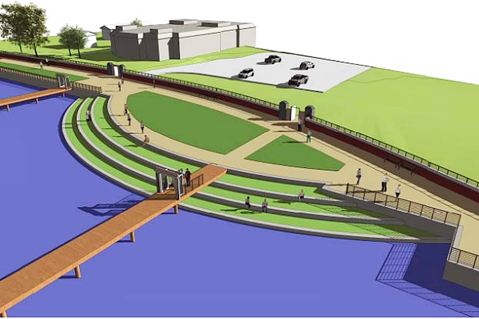
According to a report from engineering firm Kerr Wood Leidal, high-water events have increased in frequency in recent years in the Shuswap. The report details a combined flood barrier and walkway which would protect buildings along the Sicamous Narrows from flooding damage and allow more public access to the waterfront.
Docks and boat launches will remain accessible with the completed barrier in place.
Although the report shows a number of possible construction options were considered, the leading option is two parallel metal sheet pile walls with a five-metre wide walkway between them.
The report notes the elevation of the planned walkway is between the 10 and 50 year return periods of the lake so it is expected to flood during significant high-water events. During these significant flooding events, access points to the walkway will be able to be fitted with modular panels to keep the high water outside the landward wall.
Along with the public walkway, the plan contains the option for a new public space, making a sediment buildup between Martin Street and Weddup Street into an area usable for a picnic or accessing the water. Plans for the public space show a grass-covered area outside the flood barrier with terraced steps down to the water made from concrete lock blocks.
Read More: Dangerous drivers prompt request from Canoe residents to Salmon Arm council
Read More: Salmon Arm care home seeks gifts to ease Christmas isolation for seniors
Kerr Wood Leidal’s report notes there will be significant environmental and archaeological considerations when undertaking a project in the narrows. It states the Sicamous Narrows has a high potential for archaeological finds and that an assessment of the area should be done before the project proceeds. The report acknowledges and budgets for unforeseen work and costs related to archaeology. It also notes that construction will have to be planned around the salmon migrations which use the channel.
The cost estimate in the report puts the total project, including a 40 per cent contingency as well as engineering, environment and archaeological concerns, at $23,850,000 for the flood protection alone, and $25,940,000 for the flood protection and the new waterfront public space.
Read More: Thieves break into, steal items from North Okanagan mailbox
Read More: Federal Court says class action on COVID-19 airfare refunds a matter for other courts
Mayor Terry Rysz said construction of the project will likely take a long time to complete but a flood mitigation plan is necessary because of the increasingly common high-water events the Sicamous area has experienced.
“Flooding in Sicamous used to happen every 20 years; now it seems to be every third year,” Rysz said.
He said a permanent flood management solution would be a proactive step rather than reactive solutions like sandbagging, which have been used to protect structures and infrastructure in the district in past years.
Government grants will be sought to fund construction of the flood barrier. Rysz said he believes money will be available for work on projects like this because of the serious impacts seasonal flooding has had on B.C. communities including Sicamous.
jim.elliot@saobserver.net
Like us on Facebook and follow us on Twitter